
Appalachian Mountains
Description
Trails in this region
Links
Facts
Reports
Guides and maps
Lodging
Organisations
Tour operators
GPS
Other
Books
Stanfords
United Kingdom
United Kingdom
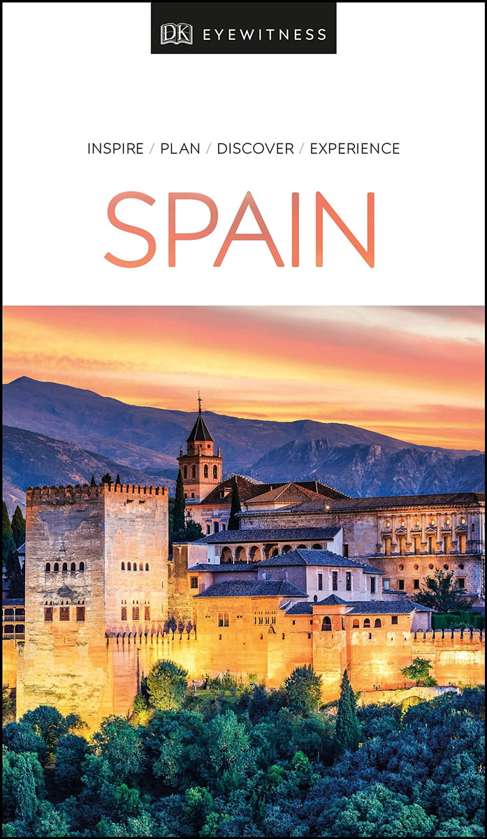
- DK Eyewitness Travel Guide Spain
- Your journey starts here. Featuring DK`s much-loved maps and illustrations, walks and information, plus all new, full-colour photography, this 100% updated guide to Spain brings you the best of this sensational country in a brand-new, lightweight format.What`s inside?- full-colour photography, hand-drawnillustrations, and maps throughout-... Read more

Stanfords
United Kingdom
United Kingdom
- Middlesex and West London - Waterside Walks
- Waterside Walks in Middlesex and West London by David and Rosemary Hall presents a selection of twenty circular walks that take in some part of a local waterway. These include the rivers Thames and Colne, the Staines Reservoirs, Dollis Brook and the Grand Union Canal. The twenty routes in this book are all between 3 to 7 miles. Each walk is... Read more

Stanfords
United Kingdom
United Kingdom
- DK Eyewitness Travel Guide Denmark
- Discover Denmark with this essential travel guide, designed to help you create your own unique trip and to transport you to this beautiful country before you`ve even packed your case. Cycle Copenhagen`s picturesque streets, explore the rugged coastline of Bornholm, swig craft beer in Aarhus or follow in the footsteps of Vikings in Viborg and... Read more

Stanfords
United Kingdom
2013
United Kingdom
2013
- Sicily: Car Tours and Walks
- Sicily is the Sunflower Landscapes guide to exploring the best walking and touring possibilities on the island. The guide covers a range of routes including walks around Mount Etna, Mount Soro, Cefalù, Mount Pellegrino and the Gran Cratere on Vulcano. A double-sided, fold-out touring map at the back of the book shows the whole island, with the... Read more

Stanfords
United Kingdom
2022
United Kingdom
2022
- DK Eyewitness Thailand
- Discover the beating heart of Southeast AsiaWhether you want to experience legendary nightlife, spectacular forests or delectable cuisine, your DK Eyewitness travel guide makes sure you experience all that Thailand has to offer.Thailand is as diverse as it is beautiful. The extensive coastline and idyllic islands offer the opportunity to dive... Read more

Stanfords
United Kingdom
United Kingdom
- DK Eyewitness Travel Guide Costa Rica
- Your journey starts here. We`ve reimagined and updated our iconic DK Eyewitness travel guides. This brand new Costa Rica guide, now in a lightweight format, has been expertly curated with all new photography plus DK`s much-loved illustrations and maps. - Gorgeous, all-new colour photography so you can imagine yourself there- Reasons to love... Read more

Stanfords
United Kingdom
2015
United Kingdom
2015
- Sorrento, Amalfi Coast and Capri: Car Tours and Walks
- Sorrento, Amalfi and Capri is the Sunflower Landscapes guide to exploring the best walking and touring possibilities in the region. The guide covers a range of routes including walks in Amalfi/Ravello, Positano/Praiano, Conca dei Marini, Maiori/Minori, Sorrento and Capri. A double-sided, fold-out touring map at the back of the book shows the... Read more

Stanfords
United Kingdom
United Kingdom
- DK Eyewitness Sicily
- Discover Sicily`s secluded coves, steaming volcanoes and storybook villages.Whether you want to visit Palermo`s cutting-edge galleries, explore mysterious ancient ruins in Segesta or hike the craterous trails around majestic Mount Etna, your DK Eyewitness travel guide makes sure you experience all that Sicily has to offer.Rising out of... Read more

Stanfords
United Kingdom
2016
United Kingdom
2016
- Pyrenees: Car Tours and Walks
- Pyrenees is the Sunflower Landscapes guide to exploring the best walking and touring possibilities in the mountain range. The guide covers a range of routes including walks in Vilajuiga, Pedraforca, the Anisclo Canyon and Roncesvalles. A double-sided, fold-out touring map at the back of the book gives an overview of the region and the locations... Read more

Stanfords
United Kingdom
United Kingdom
- Walking Prague: The Best of the City
- See the best of Prague with this streamlined walking guide, complete with step-by-step itineraries and maps, to help you explore the city like a pro and navigate like a local. Created in a handy, take-along format, this guide is written by a seasoned travel writer to help conjure the spirit of the place in elegant text enhanced by National... Read more

Stanfords
United Kingdom
United Kingdom
- Rick Steves Pocket Prague (Second Edition)
- Make the most of every day and every dollar with Rick Steves! This colourful, compact guidebook is perfect for spending a week or less in Prague:City walks and tours: Five detailed self-guided walks, including a walk from the Old Town Square to the Charles Bridge and tours of The Jewish Quarter and Prague Castle- Rick`s strategic advice on... Read more
Stanfords
United Kingdom
United Kingdom
- New York`s 50 best places to take tea
- Taking tea is a convivial activity--a perfect way for friends to get together--and yet the ritual is also contemplative. Simultaneously stimulating and soothing, tea relaxes the body and rejuvenates the soul. In New York City, the venues for taking tea are as varied as the delights of the brew itself. Completely revised and updated for its new... Read more

Stanfords
United Kingdom
United Kingdom
- Explorers: Amazing Tales of the World`s Greatest Adventures
- Meet famous explorers and adventurers in this exciting non-fiction storybook for children. Venture into steaming jungles in search of lost temples, fight off frostbite in the Arctic, and blast off into space!Great explorers have one thing in common - a desire to leap into the unknown, no matter how dangerous that might be. From Ferdinand... Read more

Stanfords
United Kingdom
2016
United Kingdom
2016
- Lonely Planet Bilbao and San Sebastian Pocket Guide
- The Lonely Planet Pocket Guide to Bilbao and San Sebastian offers frank and informal advice on an extensive range of sights, activities, accommodation, restaurants and nightlife. Gawk at the Museo Guggenheim in Bilbao, soak in the history at Guernica and explore the perfect city beach.Written and researched by a team of experts, this book is... Read more

Stanfords
United Kingdom
United Kingdom
- Fuerteventura
- Fuerteventura in the Sunflower Landscapes guide series; exploring the best walking and touring possibilities in the region or area. Detailed information about touring by hired car or public transport, as well as on foot is provided, helping walkers to navigate and plan day-trips. Shorter strolls are also included as an alternative for each main... Read more
Maps

Stanfords
United Kingdom
United Kingdom
- Ganesh Himal 2885-09
- Ganesh Himal, sheet no. 2885-09, in the topographic survey of Nepal at 1:50,000 published by the Nepali Government in the late 1990s and early 2000s and produced from remote sensing data by Finnish cartographers as part of that country’s international aid program. The maps cover 15’ x 15’ quadrangles.IMPORTANT – PLEASE NOTE BEFORE ORDERING:... Read more
Stanfords
United Kingdom
United Kingdom
- Gamaar
- Gamaar, sheet no. 2984-09, in the topographic survey of Nepal at 1:50,000 published by the Nepali Government in the late 1990s and early 2000s and produced from remote sensing data by Finnish cartographers as part of that country’s international aid program. The maps cover 15’ x 15’ quadrangles.IMPORTANT – PLEASE NOTE BEFORE ORDERING:... Read more
Stanfords
United Kingdom
United Kingdom
- Dhunche (2885 14)
- Upper Langtang Valley, sheet no. 2885-15, in the topographic survey of Nepal at 1:50,000 published by the Nepali Government in the late 1990s and early 2000s and produced from remote sensing data by Finnish cartographers as part of that country’s international aid program. The maps cover 15’ x 15’ quadrangles.IMPORTANT – PLEASE NOTE BEFORE... Read more
Stanfords
United Kingdom
United Kingdom
- Koban
- Koban, sheet no. 2883-07, in the topographic survey of Nepal at 1:50,000 published by the Nepali Government in the late 1990s and early 2000s and produced from remote sensing data by Finnish cartographers as part of that country’s international aid program. The maps cover 15’ x 15’ quadrangles.IMPORTANT – PLEASE NOTE BEFORE ORDERING:... Read more
Stanfords
United Kingdom
United Kingdom
- Hongu Khola - Chheskam
- Hongu Khola - Chheskam, sheet no. 2786-08, in the topographic survey of Nepal at 1:50,000 published by the Nepali Government in the late 1990s and early 2000s and produced from remote sensing data by Finnish cartographers as part of that country’s international aid program. The maps cover 15’ x 15’ quadrangles.IMPORTANT – PLEASE NOTE BEFORE... Read more
Stanfords
United Kingdom
United Kingdom
- Bhijer
- Bhijer, sheet no. 2982-12, in the topographic survey of Nepal at 1:50,000 published by the Nepali Government in the late 1990s and early 2000s and produced from remote sensing data by Finnish cartographers as part of that country’s international aid program. The maps cover 15’ x 15’ quadrangles.IMPORTANT – PLEASE NOTE BEFORE ORDERING:... Read more
Stanfords
United Kingdom
United Kingdom
- Somdan
- Somdan, sheet no. 2885-13, in the topographic survey of Nepal at 1:50,000 published by the Nepali Government in the late 1990s and early 2000s and produced from remote sensing data by Finnish cartographers as part of that country’s international aid program. The maps cover 15’ x 15’ quadrangles.IMPORTANT – PLEASE NOTE BEFORE ORDERING:... Read more
Stanfords
United Kingdom
United Kingdom
- Dhaina
- Dhaina, sheet no. 2981-08, in the topographic survey of Nepal at 1:50,000 published by the Nepali Government in the late 1990s and early 2000s and produced from remote sensing data by Finnish cartographers as part of that country’s international aid program. The maps cover 15’ x 15’ quadrangles.IMPORTANT – PLEASE NOTE BEFORE ORDERING:... Read more
Stanfords
United Kingdom
United Kingdom
- Khiji Phalate
- Khiji Phalate, sheet no. 2786-10, in the topographic survey of Nepal at 1:50,000 published by the Nepali Government in the late 1990s and early 2000s and produced from remote sensing data by Finnish cartographers as part of that country’s international aid program. The maps cover 15’ x 15’ quadrangles.IMPORTANT – PLEASE NOTE BEFORE ORDERING:... Read more
Stanfords
United Kingdom
United Kingdom
- Chainpur
- Chainpur, sheet no. 2981-05, in the topographic survey of Nepal at 1:50,000 published by the Nepali Government in the late 1990s and early 2000s and produced from remote sensing data by Finnish cartographers as part of that country’s international aid program. The maps cover 15’ x 15’ quadrangles.IMPORTANT – PLEASE NOTE BEFORE ORDERING:... Read more
Stanfords
United Kingdom
United Kingdom
- Nile
- Nile, sheet no. 2885-05, in the topographic survey of Nepal at 1:50,000 published by the Nepali Government in the late 1990s and early 2000s and produced from remote sensing data by Finnish cartographers as part of that country’s international aid program. The maps cover 15’ x 15’ quadrangles.IMPORTANT – PLEASE NOTE BEFORE ORDERING:... Read more

Stanfords
United Kingdom
United Kingdom
- Europe High 5 Edition Camping Atlas
- The first physical atlas with direct access to useful additional information from the InternetThe entirety of Europe on 432 pages in a scale of 1:800,000 clearly presented, including lots more travel information:- Road Companion (roadmaps) in a scale of 1:800,000, inclusive of the High 5 - Edition app technology for calling up additional travel... Read more
Stanfords
United Kingdom
United Kingdom
- Damodar Kunda
- Damodar Kunda, sheet no. 2984-13, in the topographic survey of Nepal at 1:50,000 published by the Nepali Government in the late 1990s and early 2000s and produced from remote sensing data by Finnish cartographers as part of that country’s international aid program. The maps cover 15’ x 15’ quadrangles.IMPORTANT – PLEASE NOTE BEFORE ORDERING:... Read more
Stanfords
United Kingdom
United Kingdom
- Sabha Khola - Chainpur
- Sabha Khola - Chainpur, sheet no. 2787-10, in the topographic survey of Nepal at 1:50,000 published by the Nepali Government in the late 1990s and early 2000s and produced from remote sensing data by Finnish cartographers as part of that country’s international aid program. The maps cover 15’ x 15’ quadrangles.IMPORTANT – PLEASE NOTE BEFORE... Read more
Stanfords
United Kingdom
United Kingdom
- Chala Bhanjyan
- Chala Bhanjyan, sheet no. 2983-06, in the topographic survey of Nepal at 1:50,000 published by the Nepali Government in the late 1990s and early 2000s and produced from remote sensing data by Finnish cartographers as part of that country’s international aid program. The maps cover 15’ x 15’ quadrangles.IMPORTANT – PLEASE NOTE BEFORE ORDERING:... Read more