
Stanfords
United Kingdom
- Eupen Mini-Ardenne
- Ardennes Recreational Maps at a scale of 1:25,000 enable you to discover the Ardennes from junction to junction, each associated with a locality, through a network of hiking, cycling or riding paths. The network of mini walks consists of suggested routes with kilometre distance marked showing field boundaries and urbanised built up areas.... Read more

Stanfords
United Kingdom
- Arlon NGI Topo 68-69
- Topographical survey of Belgium at 1:50,000 from the country’s national survey organization, Nationaal Geografisch Instituut / Institut Géographique National. Contour interval varies according to the terrain, from 2.5 metres in the coastal areas to 10 metres in the Ardennes. The maps provide all the information expected of topographic mapping... Read more
Stanfords
United Kingdom
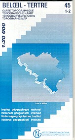
- Beloeil - Boudour
- Topographical survey of Belgium at 1:20,000 from Nationaal Geografisch Instituut / Institut Géographique National, the country’s national survey organization. Each 20K map covers one quarter of the corresponding 1:50,000 map (with adjustments in the border and coastal areas). The maps provide all the information expected of topographic mapping... Read more

Stanfords
United Kingdom
- World War I Macedonian Front: Couronne
- Couronne, one of two maps covering the site of the Battle of Doiran between British and Greek troops against Bulgarian forces on the Macedonian Front during World War I. Both maps are reproductions by G.H. Smith & Son of the original British Army trench maps at approximately 7/10th of the original scale quoted against each title.This title, the... Read more

Stanfords
United Kingdom
- Anthisnes - Comblain-au-Pont
- Topographical survey of Belgium at 1:20,000 from Nationaal Geografisch Instituut / Institut Géographique National, the country’s national survey organization. Each 20K map covers one quarter of the corresponding 1:50,000 map (with adjustments in the border and coastal areas). The maps provide all the information expected of topographic mapping... Read more

Stanfords
United Kingdom
- Moulin-Manteau - Moulin-de-Chestion
- Topographical survey of Belgium at 1:20,000 from Nationaal Geografisch Instituut / Institut Géographique National, the country’s national survey organization. Each 20K map covers one quarter of the corresponding 1:50,000 map (with adjustments in the border and coastal areas). The maps provide all the information expected of topographic mapping... Read more
Stanfords
United Kingdom
- Florenville - Chiny
- Topographical survey of Belgium at 1:20,000 from Nationaal Geografisch Instituut / Institut Géographique National, the country’s national survey organization. Each 20K map covers one quarter of the corresponding 1:50,000 map (with adjustments in the border and coastal areas). The maps provide all the information expected of topographic mapping... Read more

Stanfords
United Kingdom
- Tongeren - Herderen
- Topographical survey of Belgium at 1:20,000 from Nationaal Geografisch Instituut / Institut Géographique National, the country’s national survey organization. Each 20K map covers one quarter of the corresponding 1:50,000 map (with adjustments in the border and coastal areas). The maps provide all the information expected of topographic mapping... Read more

Stanfords
United Kingdom

Stanfords
United Kingdom
- Roeselare NGI Topo 19-20 - WWI Ypres Salient Battlefields
- Roeselare, map No. 19-20 in the topographic survey of Belgium at 1:50,000 covering the northern sector of the Ypres Salient battleground of World War I, north of the Paschendaele/Passendale – Boezinge line, including Steenstraat. Map legend includes English.Although not specifically designed to highlight locations connected with WWI, the map... Read more
Stanfords
United Kingdom
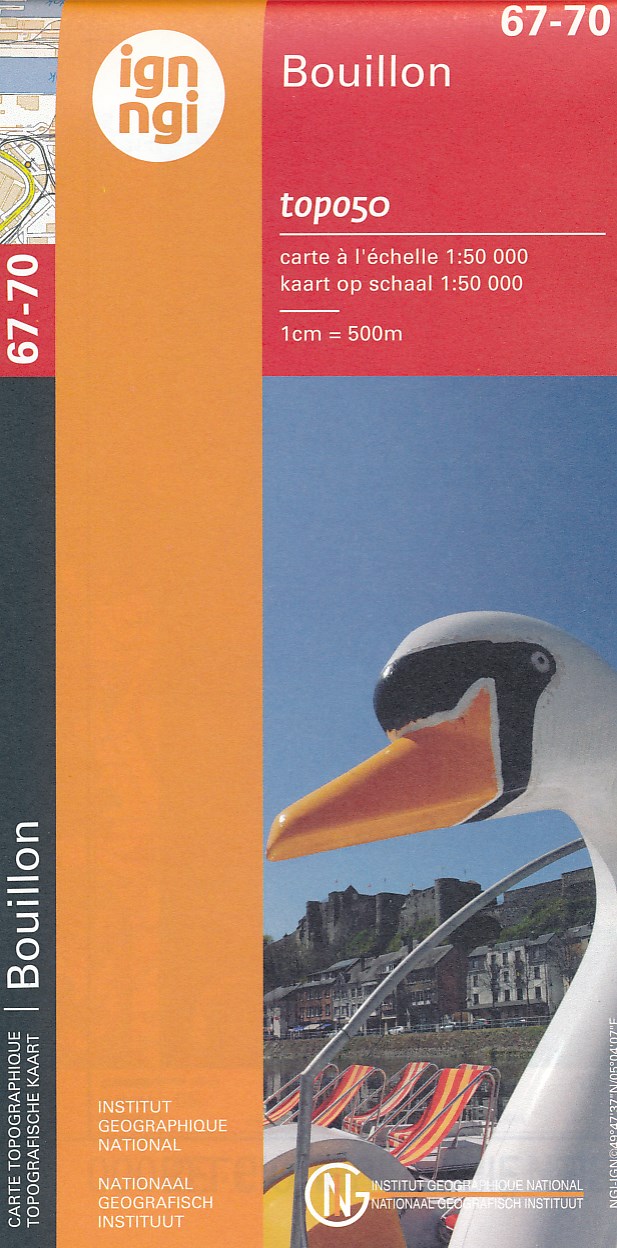
- Bouillon NGI Topo 67-70
- Topographical survey of Belgium at 1:50,000 from the country’s national survey organization, Nationaal Geografisch Instituut / Institut Géographique National. Contour interval varies according to the terrain, from 2.5 metres in the coastal areas to 10 metres in the Ardennes. The maps provide all the information expected of topographic mapping... Read more
Stanfords
United Kingdom
- Jurbise - Obourg
- Topographical survey of Belgium at 1:20,000 from Nationaal Geografisch Instituut / Institut Géographique National, the country’s national survey organization. Each 20K map covers one quarter of the corresponding 1:50,000 map (with adjustments in the border and coastal areas). The maps provide all the information expected of topographic mapping... Read more

Stanfords
United Kingdom
- World War I Macedonian Front: Lake Dorjan
- Lake Dorjan, one of two maps covering the site of the Battle of Doiran between British and Greek troops against Bulgarian forces on the Macedonian Front during World War I. Both maps are reproductions by G.H. Smith & Son of the original British Army trench maps at approximately 7/10th of the original scale quoted against each title.This title,... Read more
Stanfords
United Kingdom
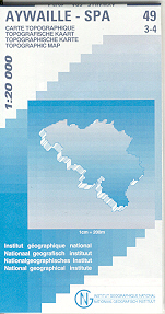
- Aywaille - Spa NGI Belgium Survey Map No. 49/3-4
- Topographical survey of Belgium at 1:20,000 from Nationaal Geografisch Instituut / Institut Géographique National, the country’s national survey organization. Each 20K map covers one quarter of the corresponding 1:50,000 map (with adjustments in the border and coastal areas). The maps provide all the information expected of topographic mapping... Read more
Stanfords
United Kingdom
- Gedinne
- Topographical survey of Belgium at 1:20,000 from Nationaal Geografisch Instituut / Institut Géographique National, the country’s national survey organization. Each 20K map covers one quarter of the corresponding 1:50,000 map (with adjustments in the border and coastal areas). The maps provide all the information expected of topographic mapping... Read more